
Steve Jobs unveiled the new iPhone 3-G, to oohs and aahs. One of its most impressive features is a pairing of GPS and mapping that allows users to instantly locate themselves and search for nearby items of interest – restaurants, shops, etc.
What will really impress me, though, is when we’re all able to see more information about people and resources. I’d bet anyone reading this can quickly search for a Starbucks, or some other commercial resource, anywhere around the globe. But what if you wanted to find which neighborhoods in your community had the highest rates of lower income Latinos with diabetes, or children living in poverty? What if you wanted to map the flow of foundation grants to various regions or neighborhoods? What if you also wanted to find, and contribute to, that information through your cell phone?
As Buckaroo Banzai and Buddhist sages put it, “wherever you go, there you are.” But for too many people around the world, the inverse is true—wherever you are determines where you can go. Place matters to our quality of life far more than whether we can find good coffee or a particular kind of food or entertainment. Our prospects for enjoying clean air and water, healthy food, freedom from violence, and opportunities to learn may be tied more closely to where we live than any other characteristic. Place is where the intersection of race, class, and power is shown in starkest relief.
Advocates, planners and funders are increasingly using GIS mapping to analyze a host of issues. Civil rights lawyers, environmental justice activists, and community organizers are using maps to anchor dialogue with community members, adding their on-the-ground knowledge to “official” data, and also to make their case to policy makers and judges. The same day as the iPhone launch, a group of academics and advocates gathered in Oakland to inform an Opportunity Agenda study on the use of maps to support health equity advocacy. Bill Lann Lee, former assistant U.S. Attorney for Civil Rights during the Clinton Administration and a co-founder of Opportunity Agenda, noted how much he and his colleagues would have liked to use maps (the way modern technology makes possible) when suing to stop the lead poisoning of low-income children or to prevent violations of voting rights. Participants heard how the Kirwan Institute and Legal Services of Northern California use maps to make powerful cases for the harmful effects of structural racism, and also about how health researchers and government agencies are using GIS to analyze health and environmental issues.
Mapping also shows great promise for making visible the flow of grant dollars to specific places, the demographic and other attributes of those places, and even the specific subsets of people served in those places. HealthyCity.org has developed innovative methods for mapping the service areas and branch locations of grantees and graphically displaying the relative size of grants, all on top of a set of more than 60 demographic and health indicators and the locations of resources such as schools, parks, fire and police stations, and other nonprofit organizations, for funders like The California Endowment, First 5 Los Angeles, and a coalition of 22 private and public funders supporting early childhood programs.
As I’ve written elsewhere, this approach holds promise not just for planning, but also for accountability and philanthropic equity issues. Mapping the reach of grants may be far better than asking individual foundations and their grantees to gather demographic and other information, as a bill in the California Assembly, AB 624, would do. To take this approach to scale, we’d need to make the grants data already disclosed by foundations more accessible to advocates, and supplement that with data about the geographic and demographic reach of those grant funds. (This would mean bringing the grants databases out from behind the firewalls of services like the Foundation Center or Foundation Search, or paying the costs of providing free public access to that data.)
At the recent NetSquared conference on innovative use of technology for social good, GIS mapping was at the core of 7 of the 21 featured projects, out of 180 nominations from around the world. Here are short summaries, in alphabetical order (complete descriptions here):
- GreenMap.org presents global information on environmental resources and challenges, by supporting creation of local green maps by users (check out their well-designed iconography).
- HealthyCity.org offers interactive access to demographics and education, health, and human services resource data for Los Angeles County (version 3.0, launching June 18, will enable users to upload and map their own data against the site’s huge database, create groups to collaborate and comment on maps, “draw” their own neighborhood boundaries, and more).
- MapLight.org maps the geography of contributors to political campaigns.
- MoveSmart.org, a tool for encouraging people in the Chicago region to find housing in diverse neighborhoods to promote fair housing and integration.
- Rosetta Project maps the location of endangered languages and linguistic groups.
- Ushahidi maps reports of post-election violence in Kenya (this won first prize).
- YourMapper.org proposes adaptation of an interactive site offering information on attributes (such as crime) and resources in the Louisville, KY metropolitan region.
Early ancestors of Web-based GIS include Neighborhood Knowledge California (developed at UCLA by Neal Richman, one of the foremost evangelists of using GIS for community benefit), and the network of sites in the National Neighborhood Indicators Project, such as Metro Boston Data Common. Recent notable developments are VolunteerMatch, which adds the ability to map volunteer opportunities, and the launch of Policy Map.
To casual observers, these mapping sites may seem alike – they all use GIS and are on the Web. On closer inspection, though, they are strikingly different. Some are interactive, others are not. Some aim to cover a huge area (wide and shallow), while others provide deeper information for more focused areas. Some are better designed to allow users to choose variables, compare more than one variable or geography, and display summary data or deeper information about data points. Some seek only to show information to visitors, others aim to gather information from users in the Web 2.0 vein, and still others have more detailed offline strategies for reaching people and groups that will actually put the information to use (you can probably guess my biases here).
Whatever you think about the potential benefits and shortcomings of GIS, we should expect this use of GIS mapping with in-depth demographic and resource data to grow quickly, and to be available over future generations of iPhones and other cell devices very soon.
Questions to address are:
- What are the types of purposes of Web-based GIS projects?
- What kinds of strategies do they follow for driving people to their sites, and for encouraging people to use (and contribute to) the information provided?
- How will Google influence, for good or ill, their development? (an issue both for those based on Google Maps and those that aren’t)
- What are, or should be, recommended practices regarding openness of programming, geo-coding, and data accessibility?
- What are the ethics of mapping (see the book How to Lie with Maps)?
Are there any questions or concerns you have about pro-social uses of GIS? Are there examples of the successful use of GIS that you’d like to share?
[Full disclosure: I am a proud co-founder and member of the governing partnership of HealthyCity.org, a project sponsored by Advancement Project, and am involved in supporting its continued development.]
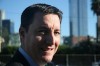 Peter Manzo is the director of strategic initiatives for the Advancement Project, a civil rights advocacy organization, and a senior research fellow with the Center for Civil Society in the UCLA School of Public Affairs. Previously, he was the executive director and general counsel of the Center for Nonprofit Management.
Read more stories by Peter Manzo.