
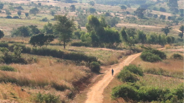
 A young girl in rural Malawi. (Photo courtesy of World Bicycle Relief)
In a small, rural village in Zambia, Ruth earns an income by collecting fresh vegetables from local community gardens and bringing them to market. Tending and collecting the vegetables by foot is time-consuming and inefficient, but with the help of a bicycle, she can travel more quickly along the 5 kilometers of dirt roads connecting the gardens and the market, increasing her earnings and savings.
Ruth’s story is compelling when you consider that 70 percent of the rural population in Africa lack access to all-season roads and reliable, affordable transport services. Most rely primarily on walking to reach their destinations. Globally, there are a staggering one billion people who live in rural areas isolated by distance, terrain, and lack of transportation. This isolation severely limits access to health care, education, nutritious and plentiful food, and economic opportunity. This lack of rural access (RA) particularly impacts young girls and women living in poverty, who are often left behind when it comes to education, health-care services, and opportunities to generate income.
These are women like Royce, a community health-care volunteer in Zambia who cares for sick adults and children in her village and surrounding areas. “I became a health-care volunteer because I have a passion for helping people,” said Royce.
When she started, the practicalities of pursuing her passions were daunting. Royce’s day would start with her waking up before dawn to complete her household chores, then walking 10 kilometers or more to reach her patients. Because of this, she could only see up to four patients a day. However, when Royce was able to start using a bicycle, she more than quadrupled the number of patients she could see to 18 per day. With 50-60 percent of people in poor countries living more than eight kilometers from health-care facilities without access to transportation, one can understand the impact that even a relatively simple solution, like a bicycle, can have on connecting people with essential services like health care.
Distance also affects girls’ access to education. Take, for example, Ethel, a 15-year-old student in rural Zambia. Like millions of girls in Africa, she had to walk to school. She’d spend over two hours each way, every day, across hilly terrain to attend school. She arrived tired with less energy for her studies, and her grades and attendance suffered. After receiving a bicycle, her commute was reduced to 45 minutes each way and she has more time and energy to devote to her studies. She even transports fellow classmates to school. That’s not a bad ROI when you consider that 32.6 million girls of primary and lower secondary school age in sub-Saharan Africa are out of school. This number rises to 52 million when taking into account girls of upper secondary school age, with millions more at risk as a result of the COVID-19 pandemic. When families lack the income for food, transport, school fees, uniforms, and essentials like menstrual products, girls are the first to drop out of school.
Despite these challenges and the significant need for solutions, rural mobility is often overlooked in global development. Governments and funders do not prioritize investing in rural access improvements due to a lack of data to make the case as well as competition from other development projects and a preference for urban investments. In Africa alone, there is an estimated infrastructure funding gap of $100 billion and the projects that do get funded are often selected based on their impact on continental trade opportunities and urban bias.
Yet there are also promising and scalable solutions to rural access improvement beyond providing bicycles. In fact, there are several organizations and a fledgling movement that is growing to address rural access barriers for the one billion people who live in rural, isolated areas in low-income countries that lack access to roads and transportation.
Scalable Solutions
Direct Investments in Scalable Infrastructure
Globally, thousands of communities are cut off from markets, health centers, and schools when rivers swell to impassable levels. Without access, these communities become isolated and, as a result, experience reduced economic, educational, and social opportunities.
Trail bridges, therefore, are a cost-effective, scalable infrastructure intervention to connect communities to services. Bridges to Prosperity (B2P), a nonprofit where two of the authors of this article work, implements trail bridges in remote, rural communities to serve pedestrian, bicycle, motorcycle, and animal traffic utilizing standardized bridge designs, recycled cable, and local materials. B2P has constructed or supported over 450 trail bridges in 21 countries, reaching over 1.5 million people. Over the past few years, they have demonstrated the ability to scale trail bridge infrastructure through a multi-year, $26 million partnership with the government of Rwanda to reach over 600,000 people nationwide. The success of scaling trail bridge infrastructure also extends beyond the Rwandan context. A partnership spanning over six decades between the government of Nepal, the Swiss Agency for Development and Cooperation, and Helvetas (where another author of this article is US CEO) has resulted in the construction and maintenance of almost 10,000 trail bridges.
We know these solutions have a great impact. Third-party researchers found that communities who received a trail bridge in Nicaragua saw a 36 percent increase in labor market income, a 75 percent increase in farm profits, and a 59 percent increase in women entering the labor market. In Nepal, trail bridges are being used by more than 2 million people every day and, on average, increasing school attendance by 16 percent and the number of patients seeking treatment in health facilities by 26 percent. Further, the researchers found that trail bridges act as self-insurance; households make more productive investments, such as purchases of farm inputs, because they are confident they can access new markets to sell their products. The positive impact on labor market income was also seen in Rwanda, where a study found a 25 percent increase in labor market income.
Beyond bridges, in rural areas of Burkina Faso, a lack of all-weather roads limited the earning opportunities of farmers and traders. Helvetas worked alongside local communities in four regions to construct and rehabilitate 436 kilometers of roads connecting 68 villages. An assessment of the impact of the new roads shows that local markets are now flourishing, with 83 percent of sellers reporting increased revenues. But the new infrastructure brought environmental benefits, too. The stone barriers featured in the design of the roads helped improve water management and mitigate the effects of floods and erosion—building communities’ resilience and supporting new agricultural activities.
An Ecosystem Approach to Mobilizing Communities
Ruth, Royce, and Ethel’s stories from the opening of this article illustrate how distance often amplifies the barriers poor families face in many low- and middle-income countries in accessing the services they need to thrive in rural areas. World Bicycle Relief (WBR), a nonprofit social enterprise (where the other two authors of this article work) helps to solve that challenge by distributing bicycles to individuals like the three women above. Because cyclists face major constraints accessing parts and service, WBR also supports a sustainable ecosystem for communities that includes access to bicycle retail networks and repair services, in both rural and urban areas, which ensures that people can maintain their bikes for many years. There are graveyards of bikes across Africa where people could not repair their bikes or get spare parts. WBR addresses this with a whole ecosystem approach.
In the past 18 years, WBR has distributed over 712,000 bicycles in 21 countries in Africa, Asia, and Latin America. Their “Mobilized Communities” model drives sustainable bicycle use through community-led, co-designed programming in health, education, livelihoods, and conservation via partnerships with non-governmental organizations, local and national governments, and the private sector. This locally based, community-driven programming includes assembly and distribution facilities, access to their spare parts supply chain, trained local mechanics, and access to its for-profit social enterprise retail outlets. Targeted rural areas benefit from 1) an infusion of quality, “fit for purpose” bicycles built specifically for harsh traveling conditions (Buffalo Bicycle), 2) locally relevant programming, and 3) mechanic training provided by World Bicycle Relief and their partners. The bicycles are designed to be a long-term productive household asset, with a low cost of ownership. Data showed that, in one community in Zambia, after one year of owning bicycles:
- The average amount of time students traveled to school was reduced by 35 percent, from 111 minutes to 73 minutes.
- Students’ safety improved: At baseline only 43 percent of children reported feeling safe traveling to school in the morning. A year later, 92 percent of children surveyed reported feeling safe.
- The average number of days children reported being late to school reduced by nearly 50 percent to 2.3 days per month.
- Ninety-five percent of respondents reported that the Buffalo Bicycle is the primary mode of transportation they use to travel to health-care facilities.
- The average time spent traveling to a health facility was reduced by 45 percent to one hour.
Meanwhile, in Zimbabwe, 60 percent of women and 45 percent of men reported that bicycles had improved their household income. Per capita monthly income increased by 55 percent from an average of US$16 in 2021, prior to bicycle ownership, to an average of US$24.90.
World Bicycle Relief’s data is further supported by the work of its partner, CAMFED, a nonprofit focused on improving girls’ access to education. CAMFED’s National Director (Malawi), Susan Silika, highlights that “[our] approach to girls’ exclusion from education and opportunity is multi-dimensional, tackling financial, psycho-social and structural barriers—and bicycles are part of the equation. Not only do bikes help students navigate long and perilous journeys more quickly and safely, aiding concentration in class and saving precious time for study; they’re also a key enabler for our graduates volunteering as ‘Learner Guides,’ who use them for their outreach to vulnerable girls in school, as well as to follow up on those pushed out of school, speaking to families and local authorities to support their return to the classroom.”
Furthermore, when community health care workers used bicycles, WBR data shows they:
- Quadrupled the frequency of visits to patients in nine provinces in Zambia.
- Kenya saw 88 percent more patients, referred 50 percent more patients for TB screening at a local clinic, and were less likely to quit.
- Doubled the number of patients they could visit in Malawi, leading to a more than 90 percent drop in patient non-compliance with long-term treatment.
Transaid, a nonprofit that works with community health workers and is a WBR partner, reported that bicycle ambulances were a contributing factor to an 87 percent reduction in the severe malaria case fatality rate with over 6,600 recipients in Zambia.
These data are just the beginning of the efforts needed to continue assessing the impact of downstream investments, and the results are showing great promise to end rural exclusion.
Democratizing Spatial Data and Mapping Applications
If you use any sort of navigation app on your phone, you understand the importance of accurate and up-to-date digital maps. Reliable spatial data is a critical component of rural access development, and despite significant leaps in mapping technology and spatial data coverage over the past two decades, the rural regions of low- and middle-income countries have largely been left behind, though they’re home to 80 percent of the world’s extreme poor. This is particularly true for routes smaller than national- or district-level roads; while a mapping application used in a major city can typically deliver several multi-modal paths with detailed directions between two points, maps of rural paths used by pedestrians, bicyclists, motorcyclists, and light vehicles are severely incomplete at best, and in many areas, non-existent. Governments generally lack the capacity to develop that critical data set at scale, and commercial interests haven’t found it profitable or compelling enough.
This data gap means that identifying, costing, and prioritizing investment in rural transportation infrastructure that connects the world’s most vulnerable populations to key destinations is exceedingly difficult, as existing tech solutions rely heavily on accurate and complete spatial data. Bridges to Prosperity is working to address this gap by collaborating with technology partners (e.g., MCGE, Autodesk, Mapbox, and Earth Lab at University of Colorado) to develop a suite of tools called Fika Map, which leverages machine learning methods and publicly available data generated by tools such as the European Space Agency’s Sentinel-2 satellites and OpenStreetMap (OSM), a free global platform that provides digital maps in rural areas through crowdsourced data, to identify barriers to transportation access in the rural context, as well as estimate the cost and social and economic return on investment to implement new infrastructure.
The “publicly available” aspect of the data is key. By building Fika Map on the few datasets that are free and globally available and integrating a growing store of training data from B2P and its partners in rural development (including end-users and community members), it enables B2P and its partners to generate and share insights and potential solutions for access with stakeholders at all levels, at no additional cost. In short, open data begets open data.
Open Source Geodata for Local Transport Planning at Scale
The global development sector and low- and middle-income governments often fail to fully evaluate access to local transportation when designing rural programs. World Bicycle Relief (WBR) is piloting a participatory geographic information system (PGIS) in Kenya, Malawi, and Zambia that uses community input and feedback to inform local transportation and infrastructure plans while minimizing environmental and social impacts. The “participatory” aspect of PGIS includes activities like drawing local maps, interviewing or surveying local residents to understand time and transport use, and transect walks to capture local knowledge and spatial information. This information combined with satellite imagery and open data sources can be used to provide a more comprehensive view of the local landscape which, in turn, helps with development planning. In rural areas, organizations are also using PGIS to plan walking and cycling routes, manage road safety, develop rural infrastructure such as bridges, and evaluate policies for their potential to improve rural access to essential services.
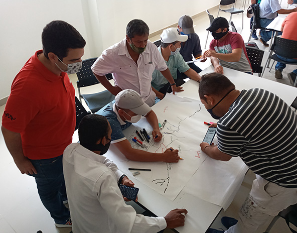 Rural residents in Colombia sketch a map of their local community. (Photo courtesy of World Bicycle Relief)
By leveraging this collective community wisdom, WBR is gaining deeper insights into available transportation options and how rural communities can use bicycles to travel further, safer, and more frequently to points of interest. Using GPS-enabled mobile phones, local community members are trained in spatial data collection and actively engage in mapping their community. Once the spatial data is collected and checked by the community, it can then be viewed on a map and used to design development programs that will improve access to critical services and opportunities.
Through this initiative, interested community members learn new skills and contribute to enhancing maps in often hard-to-reach rural areas. The combination of documenting local community knowledge (i.e., map sketching, surveys, etc.), and using spatial data capture tools (i.e., mobile phones and software) creates a digital platform that is essentially an open-source toolkit, which can be customized by other users for transportation assessment and planning needs. The resulting PGIS geodatabase can be used for local transport planning and can also be widely shared through integration with OpenStreetMap (OSM).
Other open-source data tools like the Rural Access Index Tool helps define and benchmark rural access around the world to help monitor and track progress, globally. Specifically, it “measur[es] people’s transport accessibility in rural areas where the majority of the poor live.” Developed in partnership with the Research for Community Access Partnership (ReCAP), TRL, and Azavea, the tool is a proof of concept that displays an estimated rural access score based on three open datasets. This important tool can provide policy makers with an estimate of absolute numbers of people (nationally, regionally, and globally) who live further than two kilometers from the nearest all-season road (a Sustainable Development Goal indicator). It can also help planners identify and prioritize areas of a country for rural development, linked with agricultural development plans and regional development plans.
Building a Movement for Rural Access
Given the solutions that have been tested and the early, promising development of new tools and data collection efforts for tracking progress and impact, the time is right for generating a larger, collective force to advance the cause of rural access among policy makers and funders. The interventions needed for rural mobility and transportation infrastructure have been clearly identified and proven to provide impact at scale. However, individual organizations working in silos cannot create the systemic change necessary to meet the needs of the one billion people who still lack access to education, health-care services, markets, and jobs.
A movement has started to end rural isolation that emphasizes global cooperation and leverages the strengths of a variety of rural access champions. Two recently launched coalitions, a joint effort between B2P and Helvetas and the Africa Network for Walking and Cycling (ANWAC) coalition, both seek to put the spotlight on the neglected topic of rural exclusion worldwide. These groups are bringing together committed government leaders, policy makers, funders, non-governmental organizations, and communities. This kind of framework has already demonstrated the power of coalitions through the recent launch of a collaboration between Bridges to Prosperity, Helvetas, and the government of Ethiopia to construct safe transport access for more than one million Ethiopians.
Further investment into these transformative networks and quality open data will help to drive much needed resources into the rural access sector and raise awareness for the fundamental Sustainable Development Goal principle of leaving no one behind. Finally, full integration of rural access into national development policies and commitments across climate, health, economic, and education sectors, will help to accelerate progress towards ending the isolation that fuels poverty and creating sustainable transport for all.
Read more stories by Susan Bornstein, Christina Barstow, Alisha Myers, Abbie Noriega & Christian Steiner.