

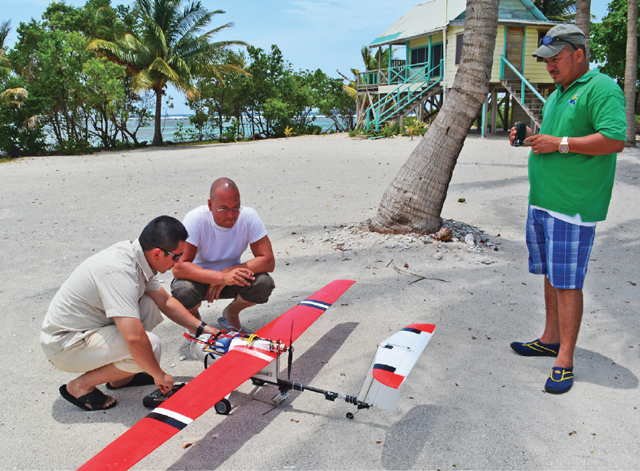
 People from ConservationDrones (left) test a drone for use in Glover's Reef, Belize. (Photo courtesy of ConservationDrones)
The Panna Tiger Reserve in Bhopal, India, is a conservation success story. After tigers disappeared entirely from the park in 2009, officials there successfully reintroduced breeding pairs of the big cats into the wild. Yet the rough terrain where tigers have found sanctuary also offers hiding places for poachers. That’s why, in 2014, the Indian government started testing the use of unmanned aerial vehicles (UAVs)—colloquially known as drones—to monitor both the endangered cats and the people who prey on them.
Conservation professionals are experimenting with similar uses of drones all around the globe: Off the coast of Belize, they’re looking for signs of illegal fishing. In Indonesia, they’re counting orangutans. In tropical rainforests, they’re monitoring plant health. Conservationists in the developing world, in fact, are moving faster on drone use than their counterparts in the United States, where regulations haven’t kept pace with the development of new research applications. The deployment of drones “is ready to expand tremendously in the conservation field,” says Richard Primack, professor of biology at Boston University and editor-in-chief of the journal Biological Conservation. “Protected areas often cover huge regions. The landscape may be extremely rugged. It’s a constant challenge to patrol for potential illegal activity or environmental damage.”
Drones, with their ability to gather high-resolution images and other data from the air, are part of the well-equipped conservationist’s toolkit, according to Serge Wich, professor of primate biology at Liverpool John Moores University in Liverpool, England, and cofounder of a small but increasingly busy nonprofit called ConservationDrones. “There’s an array of sensors we can use to monitor our planet,” he says.
Wich and his colleague Lian Pin Koh, associate professor of applied ecology and conservation at the University of Adelaide in Australia, came to the idea of using UAVs out of frustration. “A few years ago, we were talking about how difficult it is to get good data on orangutans,” Wich recalls. “Populations are spread over large areas [in Southeast Asia] that are difficult to survey. What if we could fly over and detect the nests they build in treetops?” Koh, by coincidence, had recently taken up the hobby of flying remote-control aircraft. So they looked into using UAVs, which have dropped in price dramatically in recent years. They put together their first conservation drone from off-the-shelf components for about $2,000. For technical help, they turned to an open-source network called DIY Drones.
The scientists conducted their first drone flights in Sumatra two years ago. “This was the perfect solution,” Wich says. “For a relatively low cost, you can get high-resolution data to look at the impacts of human activities like logging or small-scale agriculture.” In four days, he and Koh flew 30 missions and collected thousands of photos as well as video footage. “We could see the leaves of trees. It was astonishing,” says Wich. Other researchers, he admits, were skeptical at first: “They’d say, ‘There they go again, playing with toys.’” No longer. Since founding ConservationDrones in 2012, Wich and Koh have consulted on flight missions and offered UAV “flight schools” in Belize, Cambodia, Nepal, and other countries.
Navigating UAV regulations, which vary from country to country, poses a challenge for conservationists. “Some are easy, some are hard, and some are not clear at all,” Wich says. In the United States, the Federal Aviation Administration (FAA) is currently reevaluating its policies on commercial and research use of UAVs. This past September, after reckoning with various privacy and safety concerns, the agency decided on a one-time basis to allow limited drone use on a handful of Hollywood sets. The FAA plans to deliver on a Congressional order to update commercial UAV regulations by late 2015.
In 2014, the US National Park Service adopted a nodrones policy for its parks. The service does make exceptions on a case-by-case basis, however. Abraham Miller-Rushing, science coordinator at Acadia National Park in Maine, recently initiated an application process so that he can use drones to monitor seabird nesting on the park’s off shore islands. Today, monitoring those islands happens once every five years, and it means sending out someone to do a manual bird count. Drones, by contrast, will offer opportunities for data collection “that would otherwise be impossible or cost-prohibitive,” Miller-Rushing says.
Read more stories by Suzie Boss.